Bounding Empires and Political/Military Networks with Archaeological Data

Journal: Journal of Globalization Studies. Volume 8, Number 1 / May 2017
The archaeological analysis of territory, boundaries, and networks in empires and polities faces two hurdles. First, the conjunction of preservation, data recovery and analysis required for rigorous reconstructions is all too rare archaeologically. Second, the archaeology of political organization took a postmodern turn in the 1990s, inhibiting quantification, measurement, and the rigorous bounding of ancient networks and polities. Nevertheless, archaeologists have developed a small toolkit to answer two key questions: Was there an empire here? and, How was it bounded? I review the relevant methods and discuss a series of empirical and conceptual caveats and complications.
The use of archaeological data to analyze territory, boundaries and networks in empires and polities faces two major hurdles, one empirical and the other conceptual and disciplinary. The empirical hurdle consists of the rarity of cases where sufficient high-quality archaeological data can be assembled to reconstruct boundaries and territory in the deep past. Like many social dynamics that archaeologists may want to analyze – from social inequality to ritual processes to kingship – the study of empires and territorial processes are most amenable to rigorous archaeological analysis when there is a favorable conjunction of preservation, sampling, field recovery, analytical methods, and research design. For some empires, in some time periods, archaeologists can reconstruct provincial dynamics in considerable detail, while in other cases little can be done.
The conceptual / disciplinary hurdle refers to the intellectual development of imperial studies in archaeology. After a heyday of methodological and conceptual work in the 1980s and 1990s, major segments of the archaeological study of complex societies took a postmodern turn, from which it has yet to fully recover. Whereas previously archaeologists had struggled with ways to bound and reconstruct empires, in recent decades such studies have been replaced with post-structural and postcolonial research that avoids territorial reconstruction or measurement. Unfortunately, the idea of using archaeological data to map the extent of an ancient empire is considered outdated by many archaeologists today.
My goal in this paper is to discuss the accomplishments and potential of archaeological research on bounding empires and polities. After a brief review of the history of research on this topic, I discuss methodological work aimed at answering two key questions: Was there an empire here? and, How was it bounded? I then explore some of the complications that affect research on these questions.
The Archaeology of Imperialism: Steps Forward, Steps Back
Prior to about 1980, archaeologists in many regions assumed that the spatial distribution of certain types of material culture could be used to trace the extent of empires (e.g., Bernal 1966). This work was most common in the provinces of historically attested expansionist empires. Fieldwork in provincial settings – starting in the 1980s – showed the inadequacy of this assumption. For example, many archaeologists had assumed that the distribution of ceramic objects of the type, Aztec III black-on-orange, was a marker of the extent of Aztec imperial expansion, at least within central Mexico. When I was first able to distinguish the pre-imperial and post-imperial intervals at Aztec-period sites the Mexican state of Morelos (in the 1980s), it became clear that this pottery type was abundant both before and after imperial expansion. It had spread through commercial exchange networks that were only indirectly linked to imperial dynamics (Smith 1987). Although arguments about whether pottery types or styles could be used as indicators of imperial presence continued in Mesoamerica and elsewhere, most archaeologists agreed that more detailed evidence was needed (e.g., Levine 2013).
The adoption of explicit models of empires (Doyle 1986; Luttwak 1976) and world systems (Chase-Dunn and Hall 1997) from other disciplines helped move the archaeological study of empires forward in the 1980s and 1990s. Also contributing to advances were the increasing numbers of fieldwork projects that used these models to gather relevant field data (Alcock 1993; Alcock, D'Altroy, Morrison, and Sinopoli 2001; Cherry 1992; Dyson 1985; Sinopoli 2001). The major methodological works I discuss below (Cherry 1987; Matthews 2003; Smith and Montiel 2001; Stark 1990) were all published in this interval or shortly after.
The penetration of postmodern ideas and approaches into archaeology, beginning in the 1980s, had a chilling effect on research to identify the existence and extent of polities with archaeological data. Instead, scholarship on political topics began to focus on the aesthetics of political performance, subjectivities, hegemony, identity, and postcolonial entanglements (Inomata 2006; Routledge 2013; Smith A. 2003; Smith 2011; Van Dommelen 2011). This trend – with its tendency to avoid measurement, quantification, and rigorous argumentation (Smith 2015) – continues to be popular with many archaeologists working on states and empires (Joyce and Barber 2015; Monroe 2013).
A common ploy by archaeologists pursuing this line of scholarship has been to claim that prior materials-based analyses of provincial conditions (using imperial or world-systems models) are guilty of portraying a ‘passive periphery’. They counter this with their own purportedly superior analysis of ‘active agency’ by provincial peoples (Gosden 2001; Stein 2002: 905–907). This critique is a red herring. Apart from the fact that it does not accurately portray the work being criticized (see Smith 2004: 88–89), it serves mainly as a device to dismiss materialist analyses in favor of postmodern-derived idealistic accounts. For scholars in this camp, tasks such as the identification of the spatial extent or chronology of imperial expansion are evidently seen as prosaic and uninteresting.
Separate from the postmodern work, scholarly trends in the social and historical sciences conspired in another way to make work on the spatial extent of empires more difficult. Spatial metaphors for states and empires in the form of filled-in boxes of territory gradually gave way to more fluid network designs. In the words of Monica Smith (2005: 832). ‘Archaeological and textual evidence suggests that ancient states are better understood through network models rather than bounded-territory models’. Similar ideas were expressed by other scholars (e.g., Berman 2005; Chase-Dunn and Hall 1997: 52; Glatz 2009). While this has been a step forward (a positive change) for most purposes, it has also signaled a step backwards in the ability to use the spatial distributions of material objects as markers for the extent of past polities. The challenge is now to find ways to integrate the generally more productive network model for polities with the use of material culture distributions to reconstruct past states and empires.
Question 1: Was There an Empire Here?
The task of identifying the existence of an ancient empire illustrates some of the difficulties of reconstructing ancient socio-political dynamics with archaeological remains. Archaeologists typically have data on the large-scale spatial distributions of material objects, styles, and symbols. How can we move from these data to realistic models of past institutions and practices? The most rigorous procedure is to derive a series of explicit alternative material or artifactual expectations for likely processes and practices, and then evaluate the data against these material culture models. Such models are based on a combination of comparative data – from history, anthropology, and other disciplines – and theoretical concepts. I discuss this process further, with respect to determining the nature of the relationship between Tula and Chichen Itza, in Smith (2007: 595–596).
For the task at hand – identifying the presence of an empire or expansionistic state – I present three schemes that have proven useful to archaeologists (Tables 1–3). As part of a paper on the relationship of the large city Teotihuacan to distant polities along Mexico's Gulf Coast, Barbara Stark (1990) presented a list of alternative processes that might have been operating (Table 1), and she discusses the material implications of each process. The methodological difficulty of using lists like this to reconstruct past political patterns is that most of these alternatives require fairly rich and well-dated archaeological data to distinguish. But without such lists, some archaeologists have resorted to impressionistic and non-empirical social reconstructions in the form of post-hoc explanations; for discussion see Smith (2007).
Table 1
Interregional relations between small and large polities
| 1 | World economy |
| 2 | Preciosities world economies |
| 3 | Rare source control strategy |
| 4 | Imperial control A. Conquest threat and asymmetrical alliance B. Conquest and indirect administration C. Conquest and direct administration |
| 5 | Elite social and political dynamics A. Status export by larger state, import by smaller B. Factional fissioning of large state; relocation to smaller C. Segmentary lingeage fissioning and expansion by conquest D. Political alliances |
| 6 | Independence and minimal interaction |
| 7 | Independence and competition |
Source: Stark 1990: 247.
In 2001 Lisa Montiel and I presented a material-culture model for identifying the presence of an empire (Smith and Montiel 2001), based on Michael Doyle's (1986) analytical framework (Fig. 1); see Table 2. Our immediate objective was to evaluate the reality of proposed empires – using archaeological data – ruled by Teotihuacan and Tula in central Mexico. We calibrated the model with the Aztec empire, whose distribution was well established with historical documentation (Berdan et al. 1996). We concluded that Teotihuacan had likely ruled an empire, but Tula had not. Shortly after, Roger Matthews (2003) criticized our scheme and published a similar material-culture model, designed for use with ancient Near Eastern empires (Table 3).
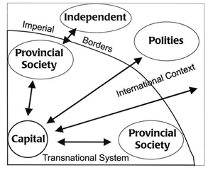
Table 2
Archaeological Criteria for the Identification of Empires
| Features | Examples |
| 1. The imperial capital A. Large, complex urban center | 1. Militarism 2. Glorification of king or state |
| 2. Domination of a territory A. Economic exchange between capital and provinces | 1. Provincial goods found at capital 2. Imperial goods found in provinces |
| B. Political control of provinces | 1. Military conquest 2. Construction of imperial infrastructure 3. Imposition of tribute or taxes 4. Reorganization of settlement systems 5. Imperial co-option of local elites |
| 3. Projection of influence in a larger international context | |
| A. Economic influence | 1. Trade with extraimperial regions |
| B. Political influence | 1. Military engagement and activities along enemy borders 2. Centralization or militarization of extraimperial polities |
| C. Cultural influence | 1. Adoption of imperial gods or rituals by distant peoples 2. Emulation of imperial styles and traits by distant peoples |
Source: Smith and Montiel 2001.
Table 3
Characteristics and correlates of empires
| Features | Examples |
| 1. Imperial Core A. Large complex urban centre as a capital B. Occupational specialization in core C. Social Stratification, from elite to slave D. Ethnic diversity at capital | |
| E. Agricultural intensification in core | 1. Crop management strategies 2. Animal management strategies |
| F. Technological advantage in core G. Imperial ideology at capital H. Militarism and use of terror. | |
| I. Glorification of state | 1. Labour investment in public building |
| J. Glorification of ruler K. Core appropriation of peripheral ideology | 1. Charismatic individual rulers |
| 2. Domination of Peripheral Polities A. Economic interaction between core and periphery via coercion/ exchange |
|
| B. Political control of periphery | 1. Military control 2. Imperial infrastructure across entire region |
| C. Imposition of tribute/tax on periphery | 1. Increased agricultural intensity in periphery 2. Intensity/standardization of craft production in the periphery |
| D. Imperial co-option of peripheral elites | 1. Peripheral elite emulation of core elite |
| 3. Empires in Global Context |
|
| A. Economic influence | 1. Trade/exchange beyond empire |
| B. Political influence | 1. Military policing of borders of empire 2. State formation in adjacent zones |
| C. Cultural influence | 1. Elite emulation of imperial styles 2. Elite emulation of imperial gods/rituals |
| 4. Cycle(s) of expansion, consolidation, collapse | |
| A. Expansion | 1. Slow-quick-slow sequence |
| B. Consolidation | |
| C. Collapse | 1. Economic downturn 2. Environmental downturn |
Source: Matthews 2003.
With explicit material-culture models and relatively rich archaeological data from a number of sites, it is usually possible to determine whether an empire existed, and whether it had conquered or incorporated a particular peripheral area. The ease of identification depends greatly on the nature of the empire; direct-rule empires, for example, are much easier to identify and map than are indirect-control empires (see discussion below, under ‘Complications’).
Question 2: How was it Bounded?
One of the fundamental difficulties in the archaeological study of borders and boundaries is chronological in nature. Archaeological chronologies may not be sufficiently fine-grained to track sociopolitical changes that may play out on a more rapid scale (Smith 1992). Imperial boundaries are often dynamic on a scale of years or decades, while archaeological time-periods may last for a century or more. The most successful studies of imperial boundaries are those that juxtapose several classes of evidence to reconstruct spatial patterns (see discussion below).
The best discussion of methods for reconstructing the borders and extent of ancient states is a chapter in an obscure volume from the 1980s (Cherry 1987). Here I update John Cherry's discussion and group the methods he covers into three categories: epigraphic evidence, linear methods, and spatial methods. While many archaeological studies of specific regions or cases employ one or more of these methods (e.g., Parker 2002), few such studies step back to generalize or to establish broader methodological guidelines.
Epigraphy
Cherry discusses epigraphic evidence – inscriptions on stone and other media, whether expressed in a written language or as symbols – in terms of their role in legitimizing state power (Cherry 1987: 168ff.). But inscriptions can also be used to reconstruct the spatial extent of polities. One of the clearest examples is the Stela of the Vultures, a monument that served as a boundary marker between the polities of Lagash and Umma in the Early Dynastic III period of ancient Mesopotamia (Winter 1985). Beyond Mesopotamia, the ‘boundary stela’ was a common form of ancient monument, with well-documented manifestations in ancient Egypt and among the Classic Maya. In the complex political landscape of the Classic Maya city-states, stone inscriptions not only reveal the relative power of kings (Martin and Grube 2000), but they also can be used to map out interactions among polities and even the extent of territories (Munson and Macri 2009).
In other cases, such as the Aztec empire, the styles and symbols of inscriptions (including both stone reliefs and mural paintings) map onto information networks (in the language of Chase-Dunn and Hall 1997) far more closely than they mark political-military networks. Authors in the volume The Postclassic Mesoamerican World (Smith and Berdan 2003) describe a modified world-systems approach that actively incorporates the transmission of symbols and styles as important world-system dynamics (Boone and Smith 2003; Smith M. 2003). Because these elements cut across polities, they are not useful for territorial reconstruction. Nevertheless, Umberger (2002) shows how key messages of imperial ideology and policy were mapped onto the imperial landscape in the outer provinces of the Aztec empire, and thus can be used to examine the extent of imperial control (see also, Sergheraert 2009).
Linear artifact distributions
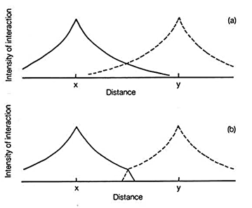
One method outlined by Cherry (1987) for reconstructing borders and boundaries is the graphing of quantitative artifact distributions along transects between production or distribution centers (Fig. 2). This method was pioneered in the archaeology of the Roman ceramic distribution in Britain (Hodder and Orton 1976), a setting with relatively rich artifact data. Although it should be possible in theory to distinguish commercial exchange that crosses political borders from exchange that is reduced or constrained by borders (Fig. 2a and b), in fact the actual distributions are frequently messy and unclear, as Cherry notes (1987: 156).
Better results might be expected with portable artifacts that have some kind of symbolic value or a particular association with a polity or its capital. The spatial distribution of coins (Collis 1981), for example, might mark the extent of a polity, as might items like ritual objects for a local or regional cult. Unfortunately, the promising work of the 1970s on using linear distributions to infer polity extent or borders was largely abandoned in subsequent decades after a leading researcher (Ian Hodder) adopted a postmodern approach.
Spatial site distributions
This category describes approaches that analyze the spatial distribution of settlements on the landscape (as contrasted with the linear distributions of particular artifact classes discussed above). The use of Thiessen polygons (or Voroni diagrams) to estimate ancient polities has a long history in archaeology (Renfrew and Cherry 1986; Wheatley and Gillings 2002). In an influential advance over this approach, Renfrew and Level (1979) developed the ‘x-tent’ model that allows the territory of a larger center to encompass or include that of smaller centers (Fig. 3). The slope of the power fall-off line determines whether the model will produce a few large polities or many small polities for a given landscape. This method has been used sporadically but fruitfully to model polities in a number of areas (Hare 2004; Redhouse and Stoddart 2011; Stoner 2012).

Distance
A common spatial distribution pattern shows open areas (‘no-man's land’) with little settlement between warring or hostile polities. These can be analyzed with simple cartographic inspection. For example, I have discussed a large open area between the hostile Aztec and Tarascan empires (Smith 1996). More sophisticated spatial methods, using nearest-neighbor analysis, cost-distance measures, and other techniques, are becoming common (Hare 2004). The most effective studies combine several spatial methods and integrate site location data with artifact distributions to produce composite models of polity distributions (Bevan 2010; Stoner 2012). These methods can only be used, however, in areas that have seen both regional site survey and excavation- or surface-based artifact collections.
Complications
A variety of features of polities and political dynamics can complicate analyses of borders and territory in the past, beyond the chronological and other issues reviewed above. I will discuss five such features: city-state cultures; non-territorial polities; and direct- vs. indirect-control empires; provincial strategies; and autocratic vs. collective regimes. The complications are of two types: complications in the organization and operation of large-scale polities or networks (Chase-Dunn and Hall 1997: 52–55), and complications in the ways that the distributions of material goods and styles map onto these networks.
City-State Cultures
Mogens Hansen defines city-state cultures as regional landscapes that are unified by language and culture yet divided into numerous small polities, or city-states (Hansen 2000b), and his edited volumes reveal a widespread distribution of this political form (Hansen 2000a, 2002). The individual polities typically interact intensively with one another in trade, diplomacy, and warfare. City-state cultures do not fit well in the nested networks scheme of Chase-Dunn and Hall (1997) because the bulk-goods network – the entire city-state culture – is larger than the political/military network.
More to the point for this paper, however, is the fact that in a city-state culture, material culture items rarely map onto polities. Instead, the relevant distributions and styles usually coincide with the (typically fuzzy) boundaries of the regional culture (Smith 2000).
Non-Territorial Polities
In the modern world and in many ancient societies, polities are defined territorially. That is, the extent of the polity is signaled by the extent of the bounded land or territory pertaining to the polity, and that territory is actively defended against outsiders. But despite claims that this kind of territoriality is a universal feature of state systems (Grosby 1995; Mann 1986: 37), there are in fact systems in which the political affiliation of individuals and households is determined by personal ties to a ruler rather than by residence location. The theoretical literature on non-territorial polities is scattered among a number of disciplines (e.g., Barth 2000; Berman 2005; Ferguson and Mansbach 1996: 34; Smith A. 2003: 153–54).
One of the most elegant and useful models of human territoriality comes from the field of behavioral ecology. Dyson-Hudson and Smith (1978) ask why territory is actively marked and defended in some societies and not in others. Their model (Fig. 4) invokes two variables. Territorial behavior is most likely where resources are both abundant (a high resource density) and predictable. This model explains variation in territorial behavior in a range of human societies. For present purposes, unless needed resources are very densely distributed, very small polities (e.g., city-states) may not encompass enough required resources to create a situation where strongly defended territory is warranted. If this is the case, then individuals may exploit more resources near their home community but their ranges may overlap with those of other polities. This is called a home-range system: organisms spend much of their time in a specific local area, but the land is not actively defended against conspecifics (see also Bintliff 1999).

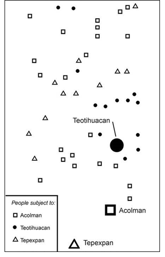
A well-known empirical case of non-territorial polities is the distribution of farming hamlets subject to three Aztec city-state kings in the Teotihuacan Valley (Fig. 5); I discuss this case elsewhere, with comparative data (Smith 2008; Tomaszewski and Smith 2011). When non-territorial polities are situated within a city-state culture – as in this Aztec example – they present the same difficulty for archaeological territorial reconstruction as described above for city-state cultures: the relevant material-culture distributions are larger than the individual polity. If they are not part of a city-state culture, then even cases where material-culture distributions or styles map onto polities will present equivocal archaeological results. The association (or lack thereof) between non-territorial polities and city-state cultures has not been analyzed, to my knowledge.
Direct vs. Indirect Control Empires
Archaeologists have long discussed the concepts of direct- and indirect-control empires, although using the labels territorial and hegemonic for these forms (Alcock et al. 2001; Berdan et al. 1996; Hassig 1985); this work grew out of the pioneering research of Edward Luttwak (1976) on the Roman Empire. New research by political scientists has new generated a better understanding of these political forms (Gerring, Ziblatt, van Gorp, and Arévalo 2011; Naseemullah and Staniland 2016; Siroky, Dzutsev, and Hechter 2013); this work provides models that work well for ancient empires. Direct-control and indirect-control empires have radically different expressions in the archaeological record. Indirect-control empires, with their much lower imperial presence in provincial areas compared to direct-control polities, yield much lower levels of imperial material culture items and styles, particularly in the realm of architecture.
A brief comparison between the Aztec (indirect-control) and Inka (direct-control) empires illustrates this point. (For the Aztec case see: Berdan et al. 1996; Sergheraert 2009; Smith 2008; for the Inka case: D'Altroy 1992; Gasparini and Margolies 1980; Hyslop 1990; Shimada 2015). Considering architecture first, civic buildings in ‘imperial’ styles were built in both the Inka and Aztec provinces. While these patterns can superficially appear similar, in fact the dynamics were quite different. The Inka Empire had a standard suite of building-types and architectural styles and techniques, and architecture was part of the overall strategy of imperial expansion and consolidation. As a result, the distribution of these elements maps rather precisely onto the spatial extent of this direct-rule empire. In the Aztec case, the ‘Aztec’ architectural style consisted of buildings and techniques that originated and spread throughout Aztec city-state culture and beyond, long before the formation of the empire. The twin-temple pyramid of Teopanzolco (in Cuernavaca), described in guidebooks as a copy of the Templo Mayor of Tenochtitlan, was in fact built prior to the foundation of the imperial capital (Smith 2008)! When this indirect-control empire conquered provincial city-states, it did not found cities or construct buildings, but its style had long preceded the expansion of the empire.
The situation for portable artifacts is less clear than architecture, but still presents a contrast between the two empires. In this case, the extreme differences in economic systems also contributed to the divergent artifactual distributions. The Aztecs had a commercial economy with money, markets, and professional merchants, whereas the Inka had a command economy that lacked these and other commercial institutions (Isaac 2013). Ceramic pots produced in and near the Aztec capital Tenochtitlan had a wide distribution in central Mexico, but as noted above these products were distributed through trade that operated both before and after the founding and expansion of the empire; they do not mark imperial extent. Inka polychrome ceramics, on the other hand, were produced and distributed through state channels (Bray 2003; D'Altroy 2001). They can therefore be used to track imperial presence and activity in provincial areas. Timothy Earle and I discuss these distinctions between Inka and Aztec imperial and economic dynamics and their expression on households in provincial areas (Earle and Smith 2012); see also Smith (2016). In sum, any use of material items by archaeologists to mark imperial expansion of needs to be based on an understanding of the nature of the particular polities; otherwise faulty conclusions can be drawn.
Provincial Strategies
Stark and Chance (2012) present a useful typology and discussion of the alternative strategies that provincial peoples engage in when dealing with distant empires or polities (Table 4). These strategies create variable spatial patterns of political power and influence, and they also create variable distribution patterns of material culture.
Table 4
Strategies of Provincial Peoples in Empires
| Strategy | |
| 1 | Bolstering. Elites and rulers seek to guarantee their own position locally and within the empire |
| 2 | Resistance. Provincial peoples seek to reduce or overthrow imperial control of local affairs. |
| 3 | Emulation. Elite and others in the province employ a prestigious style associated with the empire. |
| 4 | Exodus. Commoners or disaffected provincial elites flee to escape imperial boundaries or administered areas. |
| 5 | Information control. Provincial peoples seek to control or conceal to their own advantage information sought by the imperial government. |
| 6 | Appropriation. Provincial peoples selectively adopt imperial procedures and institutions and use them to further local ends. |
| 7 | Assertion. Provincial peoples seek to redefine to their advantage or seek exemption from imperial procedures and institutions. |
| 8 | Complicity. Elites in the province collaborate economically with significant imperial others to further their own interests. |
| 9 | Assimilation. Elites or commoners in the province, as individuals or groups, seek varying degrees of social, economic, or identity integration with the dominant societies |
Source: Stark and Chance 2012.
Autocratic vs. Collective Regimes
A major advance in understanding the variability in premodern state regimes was signaled by Blanton and Fargher's (2008) book. They construct a numerical scale of autocratic to collective rule, based on a series of variables that measure public goods provision, level of bureaucratization, and degree of control of principals. Within the bounds of the state, the level of autocratic vs. collective rule has clear material-culture expressions, parallel to the contrast between indirect and direct-control empires: collective regimes provide far more public goods, including infrastructure, temples, and other urban services with clear material expressions.
Blanton and Fargher's model remains underdeveloped with respect to the goals of this paper, for several reasons. First, they have been slow to develop a material-culture model for their scale that will facilitate archaeological application (for some progress on this, see Fargher, Heredia Expinoza, and Blanton 2011; Huster 2016). Second, it is not clear how their analysis of within-polity dynamics would play out on a larger, imperial, level. For example, elites may actively collaborate [with?] the ‘enemy’ elites at the same time their polities are at war (Smith 1986), as in several of the provincial strategies listed in Table 4. Nevertheless, the form of autocratic or collective rule is another complicating factor that needs to be taken into account in any archaeological analysis of the material expression of large-scale imperial or world-system processes.
Where do Things Stand?
I return to the problems of data quality and quantity mentioned at the outset. In situations where archaeologists have done considerable fieldwork that has generated both regional spatial data and quantifiable artifactual data, with good chronological control, we can develop robust spatial models for the extent and boundaries of ancient empires and states. Two exemplary recent case studies are Bevan (2010) and Stoner (2012). Unfortunately, such studies typically cover a relatively small part of any ancient empire or polity. A major challenge now is to develop more detailed and reliable material culture models of empires and polities that can be applied to the lower intensity data that characterizes most parts of ancient polities.
It is all well and good to point out that network models are superior to static territorial models for understanding the spatial dimensions of political dynamics in the past (Berman 2005; Chase-Dunn and Hall 1997: 52; Glatz 2009; Smith 2005). But can those network models be operationalized over larger areas, in cases that have much thinner data than covered by the case studies of Bevan (2010) and Stoner (2012)? This remains to be seen.
One option is to conclude that archaeological data are just not up to the task of reconstructing polities and networks in the past. This seems to be the attitude of Chase-Dunn et al. (2016), whose ‘rules of thumb’ for delineating past interaction networks are not workable with archaeological data. This option leads to two possible outcomes: either one's accounts of deep history will be poorly supported and idiosyncratic, or else one's samples will be limited to more recent periods that have considerable historical documentation. If, on the other hand, one takes a more optimistic view of the ability of archaeology to contribute to large-scale comparative projects, then a dedicated program of intensive coding – sensitive to archaeological data – is required. Such projects do exist (e.g., Sabloff and Cragg 2015; Smith et al. n.d.; Turchin et al. 2015), but they take considerable time and effort to develop and carry out in a rigorous fashion.
Acknowledgements
I thank the organizers of the Systemic Boundaries workshop for the invitation to write this paper. Barbara Stark and Wes Stoner provide helpful comments on an earlier draft. I thank the participants of the workshop for stimulating discussions.
Alcock, S. E. 1993. Graecia Capta: The Landscapes of Roman Greece. New York: Cambridge University Press.
Alcock, S. E., D'Altroy, T. N., Morrison, K. D., and Sinopoli, C. M. 2001. Empires: Perspectives from Archaeology and History. New York: Cambridge University Press.
Barth, F. 2000. Boundaries and Connections. In Cohen, A. P. (ed.), Signifying Identities: Anthropological Perspectives on Boundaries and Contested Values (pp. 17–36). New York: Routledge.
Berdan, F. F., Blanton, R. E., Boone, E. H., Hodge, M. G., Smith, M. E., and Umberger, E. 1996. Aztec Imperial Strategies. Washington, DC: Dumbarton Oaks.
Berman, M. L. 2005. Boundaries or Networks in Historical GIS: Concepts of Measuring Space and Administrative Geography in Chinese History. Historical Geography 33: 118–133.
Bernal, I. 1966. Teotihuacan: ¿Capital de imperio? Revista Mexicana de Estudios Antropológicos 20: 95–110.
Bevan, A. 2010. Political Geography and Palatial Crete. Journal of Mediterranean Archaeology 23: 27–54.
Bintliff, J. 1999. Settlement and Territory. In Barker, G. (ed.), Companion Encyclopedia of Archaeology, vol. 1 (pp. 505–545). London: Routledge.
Blanton, R. E., and Fargher, L. F. 2008. Collective Action in the Formation of Pre-Modern States. New York: Springer.
Boone, E. H., and Smith, M. E. 2003. Postclassic International Styles and Symbol Sets. In Smith, M. E., and Berdan, F. F. (eds.), The Postclassic Mesoamerican World (pp. 186–193). Salt Lake City: University of Utah Press.
Bray, T. L. 2003. Inka Pottery as Culinary Equipment: Food, Feasting, and Gender in Imperial State Design. Latin American Antiquity 14: 3–28.
Chase-Dunn, C., and Hall, T. D. 1997. Rise and Demise: Comparing World-Systems. Boulder: Westview Press.
Chase-Dunn, C., Hiroko, I., and Neal, T. 2016. High Bar Rules of Thumb for Time-Mapping Systemic Human Interaction Networks, vol. 105. Institute for Research on World Systems.
Cherry, J. F. 1987. Power in Space: Archaeological and Geographical Studies of the State. In Wagstaff, J. M. (ed.), Landscape and Culture: Geographical and Archaeological Perspectives (pp. 146–172). London: Blackwell.
Cherry, J. F. 1992. Archaeology of Empires.World Archaeology 23(2).
Collis, J. 1981. A Typology of Coin Distributions. World Archaeology 13: 122–128.
D'Altroy, T. N. 1992. Provincial Power in the Inka Empire. Washington D.C.: Smithsonian Institution Press.
D'Altroy, T. N. 2001. State Goods in the Domestic Economy: The Inka Ceramic Assemblage. In D'Altroy, T. N., and Hastorf, C. A. (eds.), Empire and Domestic Economy (pp. 243–264). New York: Plenum.
Doyle, M. W. 1986. Empires. Ithaca: Cornell University Press.
Dyson, S. L. 1985. Comparative Studies in the Archaeology of Colonialism, vol. 233. Oxford: British Archaeological Reports.
Dyson-Hudson, R., and Smith, E. A. 1978. Human Territoriality: An Ecological Reassessment. American Anthropologist 80: 21–41.
Earle, T., and Smith, M. E. 2012. Households, Economies, and Power in the Aztec and Inka Imperial Provinces. In Smith, M. E. (ed.), The Comparative Archaeology of Complex Societies (pp. 238–284). New York: Cambridge University Press.
Fargher, L. F., Heredia Expinoza, V. Y., and Blanton, R. E. 2011. Alternative Pathways to Power in Late Postclassic Highland Mesoamerica. Journal of Anthropological Archaeology 30: 306–326.
Ferguson, Y. H., and Mansbach, R. W. 1996. Polities: Authority, Identities, and Change. Columbia: University of South Carolina Press.
Gasparini, G., and Margolies, L. 1980. Inca Architecture. Transl. by P. J. Lyon. Bloo-mington: Indiana University Press.
Gerring, J., Ziblatt, D., van Gorp, J., and Arévalo, J. 2011. An Institutional Theory of Direct and Indirect Rule. World Politics 63: 377–433.
Gibson, Ch. 1964. The Aztecs Under Spanish Rule: A History of the Indians of the Valley of Mexico, 1519–1810. Stanford: Stanford University Press.
Glatz, C. 2009. Empire as Network: Spheres of Material Interaction in Late Bronze Age Anatolia. Journal of Anthropological Archaeology 28: 127–141.
Gosden, Ch. 2001. Postcolonial Archaeology: Issues of Culture, Identity, and Knowledge. In Hodder, I. (ed.), Archaeological Theory Today (pp. 241–261). Oxford: Polity Press.
Grosby, S. 1995. Territoriality: The Transcedental, Primordial Feature of Modern Societies. Nations and Nationalism 1: 143–162.
Hansen, M. H. 2000a. A Comparative Study of Thirty City-State Cultures. Copenhagen: The Royal Danish Academy of Sciences and Letters.
Hansen, M. H. 2000b. Introduction: The Concepts of City-State and City-State Culture. In Hansen, M. H. (ed.), A Comparative Study of Thirty City-State Cultures (pp. 11–34). Copenhagen: The Royal Danish Academy of Sciences and Letters.
Hansen, M. H. 2002. A Comparative Study of Six City-State Cultures. Copenhagen: The Royal Danish Academy of Sciences and Letters.
Hare, T. S. 2004. Using Measures of Cost Distance in the Estimation of Polity Boundaries in the Postclassic Yautepec Valley, Mexico. Journal of Archaeological Science 31: 799–814.
Hassig, R. 1985. Trade, Tribute, and Transportation: The Sixteenth Century Political Economy of the Valley of Mexico. Norman: University of Oklahoma Press.
Hodder, I., and Orton, C. 1976. Spatial Analysis in Archaeology. New York: Cambridge University Press.
Huster, A. C. 2016. Effects of Aztec Conquest on Provincial Households at Calixtlahuaca, Mexico. Ph.D. Dissertation Thesis, Arizona State University, Tempe.
Hyslop, J. 1990. Inka Settlement Planning. Austin: University of Texas Press.
Inomata, T. 2006. Plazas, Performers, and Spectators: Political Theaters of the Classic Maya. Current Anthropology 47: 805–842.
Isaac, B. L. 2013. Discussion. In Hirth, K. G., and Pillsbury, J. (eds.), Merchants, Markets, and Exchange in the Pre-Columbian World (pp. 435–448). Washington, DC: Dumbarton Oaks.
Joyce, A. A., and Barber, S. B. 2015. Ensoulment, Entrapment, and Political Centralization: A Comparative Study of Religion and Politics in Later Formative Oaxaca. Current Anthropology 56: 819–847.
Levine, M. N. 2013. Examining Ceramic Evidence for the Zapotec Imperialism Hypothesis in the Lower Río Verde Region of Oaxaca, Mexico. In Joyce, A. A. (ed.), Polity and Ecology in Formative Period Coastal Oaxaca (pp. 227–263). Bounder: University Press of Colorado.
Luttwak, E. N. 1976. The Grand Strategy of the Roman Empire From the First Century A.D. to the Third. Baltimore: Johns Hopkins University Press.
Mann, M. 1986. The Sources of Social Power. Vol. 1. A History of Power from the Beginning to A.D. 1760. New York: Cambridge University Press.
Martin, S., and Grube, N. 2000. Chronicle of the Maya Kings and Queens: Deciphering the Dynasties of the Ancient Maya. New York: Thames and Hudson.
Matthews, R. 2003. Archaeologies of Empire. In Matthews, R. (ed.), Archaeology of Mesopotamia: Theories and Approaches (pp. 127–154). New York: Routledge.
Monroe, J. C. 2013. Power and Agency in Precolonial African States. Annual Review of Anthropology 42: 17–35.
Munson, J. L., and Macri, M. J. 2009. Sociopolitical Network Interactions: A Case Study of the Classic Maya. Journal of Anthropological Archaeology 28: 424–438.
Naseemullah, A., and Staniland, P. 2016. Indirect Rule and Varieties of Governance. Governance 29: 13–30.
Parker, B. J. 2002. At the Edge of Empire: Conceptualizing Assyria's Anatolian Frontier ca. 700 BC. Journal of Anthropological Archaeology 21: 371–395.
Redhouse, D. I., and Stoddart, S. 2011. Mapping Etruscan State Formation. In Terrenato, N. and Haggis, D. C. (eds.), State Formation in Italy and Greece: Questioning the Neoevolutionist Paradigm (pp. 162–178). Oxford: Oxbow.
Renfrew, C., and Cherry, J. F. 1986. Peer Polity Interaction and Socio-Political Change. New York: Cambridge University Press.
Renfrew, C., and Level, E. V. 1979. Exploring Dominance: Predicting Polities from Centers. In Renfrew, C., and Cooke, K. L. (eds.), Transformations: Mathematical Approaches to Culture Change (pp. 145–167). New York: Academic Press.
Routledge, B. 2013. Archaeology and State Theory: Subjects and Objects of Power. London: Bloomsbury.
Sabloff, P. L. W., and Cragg, S. 2015. Status and Role in Early States: A Comparative Analysis. SFI Working Paper: 15-10-018. Santa Fe: Santa Fe Institute.
Sergheraert, M. 2009. L'expansion mexica (1430–1520 après J.-C.): La question du contrôle impérial dans les provinces extérieures de l'Empire. Ph. D. dissertation Thesis. Archaeology, Université Paris 1, Panthéon-Sorbonne, Paris.
Shimada, I. 2015. The Inka Empire: A Multidisciplinary Approach. Austin: University of Texas Press.
Sinopoli, C. M. 2001. Empires. In Feinman, G. M., and Price, T. D. (eds.), Archaeology at the Millennium: A Sourcebook (pp. 439–471). New York: Kluwer.
Siroky, D. S., Dzutsev, V., and Hechter, M. 2013. The Differential Demand for Indirect Rule: Evidence from the North Caucasus. Post-Soviet Affairs 29: 268–286.
Smith, A. T. 2003. The Political Landscape: Constellations of Authority in Early Complex Polities. Berkeley: University of California Press.
Smith, A. T. 2011. Archaeologies of Sovereignty. Annual Review of Anthropology 40: 415–432.
Smith, M. E. 1986. The Role of Social Stratification in the Aztec Empire: A View From the Provinces. American Anthropologist 88: 70–91.
Smith, M. E. 1987. The Expansion of the Aztec Empire: A Case Study in the Correlation of Diachronic Archaeological and Ethnohistorical Data. American Antiquity 52: 37–54.
Smith, M. E. 1992. Braudel's Temporal Rhythms and Chronology Theory in Archaeology. In Knapp, A. B. (ed.), Annales, Archaeology, and Ethnohistory (pp. 23–34). New York: Cambridge University Press.
Smith, M. E. 1996. The Strategic Provinces. In Berdan, F. F., Blanton, R. E., Boone, E. H., Hodge, M. G., Smith, M. E., and Umberger, E. (eds.), Aztec Imperial Strategies (pp. 137–150). Washington, DC: Dumbarton Oaks.
Smith, M. E. 2000. Aztec City-States. In Hansen, M. H. (ed.), A Comparative Study of Thirty City-State Cultures (pp. 581–595). Copenhagen: The Royal Danish Academy of Sciences and Letters.
Smith, M. E. 2003. Information Networks in Postclassic Mesoamerica. In Smith, M. E., and Berdan, F. F. (eds.), The Postclassic Mesoamerican World (pp. 181–185). Salt Lake City: University of Utah Press.
Smith, M. E. 2004. The Archaeology of Ancient State Economies. Annual Review of Anthropology 33: 73–102.
Smith, M. L. 2005. Networks, Territories and the Cartography of Ancient States. Annals of the Association of American Geographers 95: 832–849.
Smith, M. E. 2007. Tula and Chichén Itzá: Are We Asking the Right Questions? In Kowalski, J. K., and Kristan-Graham, C. (eds.), Twin Tollans: Chichén Itzá, Tula, and the Epiclassic to Early Postclassic Mesoamerican World (pp. 579–617). Washington, DC: Dumbarton Oaks.
Smith, M. E. 2008. Aztec City-State Capitals. Gainesville: University Press of Florida.
Smith, M. E. 2015. How can Archaeologists Make Better Arguments? The SAA Archaeological Record 15: 18–23.
Smith, M. E. 2016. At Home with the Aztecs: An Archaeologist Uncovers their Domestic Life. New York: Routledge.
Smith, M. E., and Berdan, F. F. 2003. The Postclassic Mesoamerican World. Salt Lake City: University of Utah Press.
Smith, M. E., and Montiel, L. 2001. The Archaeological Study of Empires and Imperialism in Prehispanic Central Mexico. Journal of Anthropological Archaeology 20: 245–284.
Smith, M. E., Stark, B. L., Chuang, W.-C., Dennehy, T., Harlan, Sh. L., Kamp-Whittaker, A., Stanley, B., and York, A. n.d. Comparative Methods for Premodern Cities: Coding for Governance and Class Mobility. Cross-Cultural Research.
Stark, B. L. 1990. The Gulf Coast and the Central Highlands of Mexico: Alternative Models for Interaction. Research in Economic Anthropology 12: 243–285.
Stark, B. L., and Chance, J. K. 2012. The Strategies of Provincials in Empires. In Smith, M. E. (ed.), The Comparative Archaeology of Complex Societies (pp. 192–237). New York: Cambridge University Press.
Stein, G. J. 2002. From Passive Periphery to Active Agents: Emerging Perspectives in the Archaeology of Interregional Interaction. American Anthropologist 104: 903–916.
Stoner, W. D. 2012. Modeling and Testing Polity Boundaries in the Classic Tuxtla Mountains, Southern Veracruz, Mexico. Journal of Anthropological Archaeology 31: 381–402.
Tomaszewski, B. M., and Smith, M. E. 2011. Politics, Territory, and Historical Change in Postclassic Matlatzinco (Toluca Valley, Central Mexico). Journal of Historical Geography 37: 22–39.
Turchin, P., Brennan, R., Currie, Th., Feeney, K., Francois, P., Hoyer, D., Manning, J., Marciniak, A., Mullins, D., Palmisano, A., Peregrine P., Turner E. A. L., and Whitehouse, H. 2015. Seshat: The Global History Databank. Cliodynamics: The Journal of Quantitative History and Cultural Evolution 6: 77–107.
Umberger, E. 2002. Imperial Inscriptions in the Aztec Landscape. In David, B., and Wilson, M. (eds.), Inscribed Landscapes: Marking and Making Place (pp. 187–199). Honolulu: University of Hawai'i Press.
Van Dommelen, P. 2011. Postcolonial Archaeologies between Discourse and Practice. World Archaeology 43: 1–6.
Wheatley, D., and Gillings, M. 2002. Spatial Technology and Archaeology: The Archaeo-logical Application of GIS. New York: Taylor and Francis.
Winter, I. J. 1985. After the Battle is Over: The Stele of the Vultures and the Beginning of Historical Narrative in the Art of the Ancient Near East. In Kessler, H. L., and Simpson, M. S. (eds.), Pictorial Narrative in Antiquity and the Middle Ages. Vol. 16, Studies in the History of Art (pp. 11–32). Washington, DC: National Gallery of Art.