State Formation and Ethnicities from 8th to 5th Century BC in the Tiberine Valley (Central Italy)


Journal: Social Evolution & History. Volume 9, Number 2 / September 2010
Abstract
Remarkable cultural differentiations occur in Central Italy since the final Bronze Age, but the rise of city-state system in the early Iron Age led to a new mosaic of ethnic identities. At the beginning this phenomenon was mainly restricted to city-states communities, but later it included also huge ethnic linguistic groups.
Between the 8th and the 5th century BC, the Tiber Valley represented the area of contact between not less than five historical ethnic groups: the Etruscans, the Faliscans, the Umbrians, the Sabinians and the Latins; it provides an opportunity to observe several regional pathways to complexity by comparing the rise and development of each ethnic groups.
To achieve this aim, the paper will focus mainly on two types of archaeological evidence: patterns of settlement and territorial organizations as markers of State complexity and ethnic identities. Within such framework ethnicity is considered a purely ideological factor but which is able to influence the evolution of landscape.
Our knowledge on ethnic groups of pre-Roman Italy starts with the regional division of Italy made by the emperor Augustus, as known mainly from Pliny the Elder (Naturalis Historia III.46) (Fig. 1).
The boundaries of these regions have been afterwards quite precisely defined since the end of the 19th century (e.g., Nissen 1902). Each region had a sequential number and a name based on the main ethnic group based in the area. So we can easily spot the Seventh region Etruria, the Sixth Umbria, the Fourth Samnium and the First Latium et Campania.
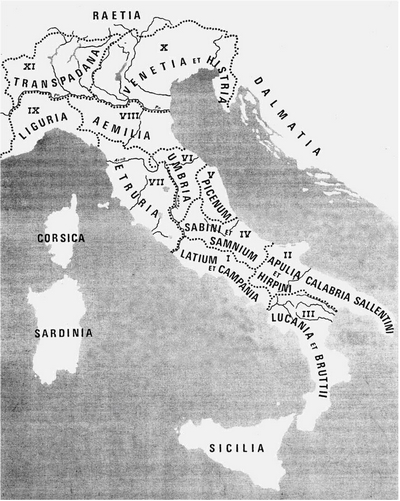
Fig. 1. The regional division of Roman Italy made by the emperor Augustus (after Piceni. Popolo d'Europa. Catalogue of the exhibition. Roma: De Luca, 2000)
However, even if we can reasonably define the borders of such regions, we must be aware of the deeply different meanings and aims of the ancient frontiers compared with those of the pre-Roman ethnic groups.
These regions had no political purpose and, above all, they did not aim to describe the complex and multi-stratified ethnic definitions of ancient pre-Roman communities, which were more often based on city-states than on huge ethnic groups.
Ethnic identity in pre-Roman Italy was often restricted to single states (especially Caere, Veii, or in Umbria: Todi and Terni, or Cures Sabini) or, more rarely, it included huge ethnic linguistic groups as the Etruscans or the Umbrians or small linguistic groups as the Falisci. The same concept of city-state (or in some cases of territorial state) was often commuted by the Romans into their main political and administrative elements: the municipium or the colonia.
To understand the patterns of settlement as evidence of ethnicity in Central Italy we must observe at regional level the evolution of city state systems through the centuries.
As a matter of fact, if the association with a specific territory is one of the bases of self-identification of an ethnic group, we can consider patterns of settlements as specific marker of ethnic definition.
Obviously, this approach can only be fruitful if we compare several patterns of settlements in the same chronological space and possibly with a similar level of documentation.
Areas near ethnic frontiers seem particularly appropriate for such analysis, and one of the most suitable region in Italy is the Tiber Valley which is the only natural pass through the Apennines, connecting the central and northern parts of the peninsula. The importance of this region for trade is stressed also by the presence of different ethnic groups (the Umbrians, Etruscans, Falisci, Sabines and Latins) who divided the area into territories from the beginning of the Iron Age, using probably the river Tiber as conventional frontier and thus this corridor provides an opportunity to observe several patterns of settlement (Fig. 2).
In Central Italy during the last phases of the Bronze Age (11th – 10th century BC) the territory was made up of a number of small fortified villages (hill-forts) between 2 and 5 hectares in size, within a radius of 4–5 km between each other, suggesting (on the basis of Thiessen polygon analysis) a territory of about 20 km2.
The landscape is considerably fragmented by the small villages, but the Tiber seems to play already an important role of demographic attraction (di Gennaro 1986; Alessandri 2007; Schiappelli 2009).
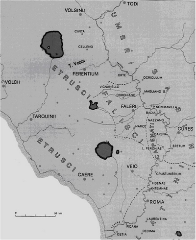
Fig. 2. The ethnic groups along the middle and lower Tiber Valley (after Colonna 1986)
This homogeneous situation was drastically modified during the first phase of the Iron Age (the end of 10th – the beginning of the 9th century BC), when we can observe the earliest demographic differentiation. In the whole Southern Etruria we have the rapid formation of four big settlements (Vulci, Tarquinii, Caere, Veii) up to 30 times huger than the previous Final Bronze Age hill-forts (Pacciarelli 2001; Vanzetti 2004).
This phenomenon is clearly visible, above all, in the lower Tiber valley, where the formation of the 175-hectare proto-urban centre of Veii caused a general depopulation of the surrounding geographic region of the future Faliscans and Sabines, and where almost all the previous Final Bronze hill-forts were abandoned. In the Sabine area especially, we have no evidence of settlements for the 9th century BC and in the future Faliscan area only a few fortified settlements survive this demographic transition(Cifani 2003 with bibliography) (Fig. 3).
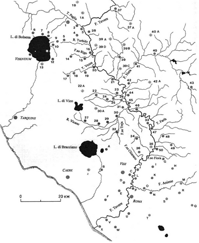
Fig. 3. The middle Tiber Valley (after Cifani 2003)
The Etruscan Volsinian area shows a less radical transformation: the central place of Volsinii (now Orvieto) had an 80-hectare fortified area on a rocky plateau and seems to have had a weaker influence on its territory in comparison with the other early Tyrrhenian states such as Veii, Caere, Tarquinia and Vulci. In fact, the territory of Orvieto was characterized by more villages in the 9th century and the transition from the Bronze Age to the Iron Age is also less evident.
On the left side of the Tiber, the Umbrian and Sabine areas seem to adopt the proto-urban system only at the end of the 8th century BC: Terni, in Umbria, with a size of 50 hectares, and Cures, in Sabina, with a size of 30 hectares are the main settlements, but for both regions the territorial organization suggests more the idea of
a medium size city-state system than the large state communities of the Etruscan area (Cifani 2003 with bibliography).
Thus, during the beginning of the Iron Age, as a result of deep demographic transformations which include for the lower Tiber valley also the foundation of Rome, the Tiber became a political and cultural boundary between different communities. The Orientalising period (710–580 BC) was characterised by the development of the secondary centres in the Etruscan area; some of them were relatively far from the main centre and seem to benefit from their frontier location.
We can quote the example of Civita di Grotte di Castro,
a 20-hectare settlement in the Volsinian area, near the political border with the territories of Tarquinii and Vulci, marked by the great lake valley of Bolsena. The necropolis of such remote community, between the end of the 7th and the beginning of the 6th century, was characterized by monumental rock-cut chambers, in some cases decorated with paintings; their tomb groups reveal the huge presence of imported Greek attic pottery and banquet services. This evidence can prove the presence of a rich aristocratic class which rose up thanks to frontier trades in the area (Cifani et al. 2010).
Another important secondary city was Acquarossa, a 50-hectare settlement in the southern area of the Vulsinian territory. This site was settled since the end of the 8th century BC and the excavations carried out by the Swedish institute found also a huge aristocratic house built in the first half of the 6th century BC in the central area of the settlement (Cifani 2003: 60–65 with bibliography).
By the midpoint of the 6th century BC, the process of state formation in Central Italy was mature, and two types of organization can be clearly seen. The first one was the large territorial state, with a hierarchical system of settlement and one central place, typical of Rome and Southern Etruscan peoples, and the second one – the city-state, with a small territory.
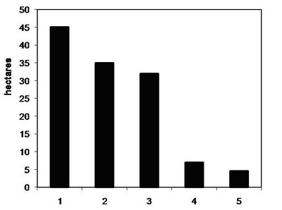
A rank size rule diagram of the settlements, divided into ethnic areas of the Middle Tiber Valley in the archaic period, shows precisely this phenomenon (Figs 4–7).
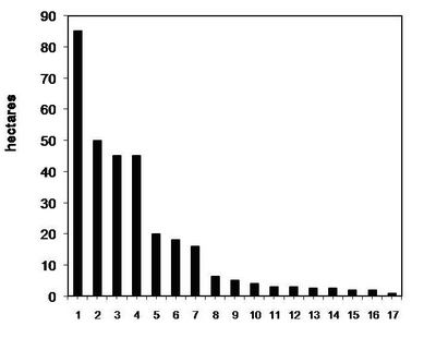
Etruscan territory of Volsinii
Territory of southern Umbria
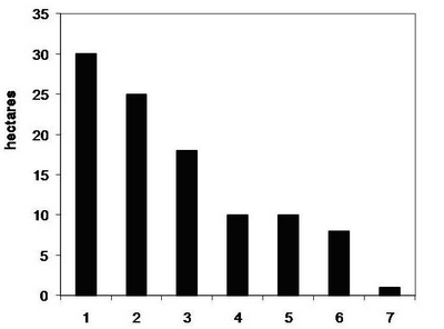
Territory of Sabina
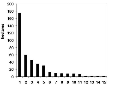
Territory of Veii
Figs 4–7. Rank size rule diagram of Middle Tiber Valley main settlements (after Cifani 2003)
The Etruscan Volsinian area reveals a three-level structure of the territory, with one central place of 80 hectares, a middle group of settlements the size of which ranges from 18 to 35 hectares, and finally a large group of small settlements, 1 to 5 hectares in size. The Etruscan Veientan area (including the ager Faliscus) shows
a similar organization, but a completely different diagram, however, is seen for the Italic regions of the Umbrians and Sabines: in both cases the graph shows few elements of diversity and the trend is quite homogeneous; this is evidence of medium city-states with their small territories. For the Etruscan lands however we note
a contrast between the urban central places, where egalitarian reforms were progressively increasing, and the peripheries, where the aristocratic groups kept and improved their power based on traditional agriculture, sheep-rearing and taxation.
In the territory of Volsinii we can observe, from the 2nd half of the 6th century BC onwards, the progressive decline of many aristocratic enclaves. The best known example is Acquarossa, where the Swedish excavations revealed the end of the centre because of a fire around the half of the 6th century BC (Strandberg Olofsson 1996: 158–159), but we could also quote the case of the frontier city of Civita di Grotte di Castro where the bulk of evidence seems concentrated on 7th and 6th century BC (Cifani et al. 2010).
There is however also a third phenomenon occurring in parallel with the above: the foundation of new small fortified settlements which started during the 6th century BC. An interesting example is represented by the site of Castellaro, a small fortified settlement of 2 hectares occupied from the 6th to the 3rd century BC, on the top of a small volcanic hill, whose natural topography appears to have been reworked (Cifani 2003: 59–60). A further example in the Volsinian territory was the small fortified site of Monterado which also dated to the 6th century BC (Quilici and Quilici Gigli 2006).
Castellaro and Monterado exemplify new colonial foundation supported by Volsinii within its territory in order to control strategic key points and to deprive the old aristocratic centres of authority and economic importance; in addition, these fortified settlements were political landmarks for people living in isolated farmhouses.
The foundation of sanctuaries and fortresses near the political borders of different communities seems to have emphasized the new social identity of the Etruscan states, controlled by central authorities instead of the previous aristocratic groups.
The new state frontiers were promptly ritualized by means of sanctuaries, adopting a tradition which has many comparisons at
an anthropological level (e.g., Barth 1969; Hodder and Orton 1976: 73; Massenzio 1999: 146–150). The rise of a new ritual landscape is also the evidence of a new cultural memory (epos) that is often related to political changes (Assmann 1992).
Regarding southern Etruria, we can focus on the position of two frontier sanctuaries: Lucus Feroniae in the Tiber valley and Fondaccio in the Volsinian lake (Cifani 2003 with bibliography).
A line of sanctuaries also marked the internal frontier between the territories of Caere and Veii and between Caere and Tarquinii from at least the end of the 6th century BC; the evidence is based on fragments of terracotta temple revetments, and votive inscriptions found along the line of both frontiers (Zifferero 1995; Cifani 2003: 193–194 with bibliography; Colonna 2005) (see Fig. 3).
A similar ritual landscape, albeit on smaller scale, also seems visible in Umbria, where the political borders of city states are marked often by peak sanctuaries on the top of mountains (Malone and Stoddart 1994: 142–152; Bradley 1997; Sisani 2001: 67–81) and even the borders of the most ancient suburb of Rome were marked by a line of sanctuaries, located along the main routes of communication, between the 4th and 6th mile from the city (Cifani 2005a with bibliography).
The Faliscan and Capena Ethnic Identity
The Faliscans have been considered since the 19th century an autonomous ethnic group of Latin origin, inside Etruria (Garrucci 1860; Deecke 1888). Their language was indeed very near to Latin (Giacomelli 1963) and according to the literary tradition, Faliscans were an autonomous ethnic group, although the theories of their origins were controversial (Camporeale 1991) (seeFig. 2). Some sources refers their mythical origin as linked to the Etruscan city of Veii (Servius ad Aeneas. VIII.285). Ancient historians refer to the military alliance of Faliscans with Veii against Rome, during
the 5th and 4th century BC (Livy IV.17–18, 21, 23–24; V.8, 17, 26–27; VII.16–22; Pliny the Elder, Naturalis Historia III.51) and later, their presence as an autonomous political entity at the pan-Etruscan meeting at Fanum Voltumnae, in 397 BC (Livy V.16.6). Then, they were considered an autonomous community with a language, different from Etruscan (Strabo V.9). Vergil imagines the Faliscans as ancient allies of the Latins against the Etruscans (Vergil Aeneid. VII.641ff.), but Cato thought they were originated from Greece (Cato, in Pliny the Elder, Naturalis HistoriaIII.51). Those data led to more extreme theories, such as an Faliscan original link with the Latin area and their political autonomy from Etruscans (Holland 1925).
Since the 1950s, the progressive publication of data from Veii made clear the strong cultural relationship between this Etruscan city and the nearby communities of Faliscans (Benedettini 1997), together with the presence of a huge number of Etruscan inscriptions found in the main Faliscan centres (Cristofani 1988; Colonna 1990; CIE II.2.5, 8889–8925). Furthermore, the settlement analysis of the early Iron Age in southern Etruria proved the precedence of the Veii over the Faliscan area. As matter of fact Veii starts as proto-urban centre already at the beginning of the early Iron Age (the 9th century BC), but the Faliscan territory starts to be re-organized only at the end of the 8th century BC. In addition, Faliscan towns show not only the strong cultural influence of Veii, but, because of their size and location on the road network leading to Veii, they were undoubtedly hierarchically subordinate to this important Etruscan city.
A further example of an ethnic group was the Capenates. According to the legend, the city of Capena was founded as a colony of Veii by means of an internal migration (Cato Orig. II.19) and, together with the Faliscans, they are reported as military allies of Veii during the wars with Rome in the 5th and 4th centuries BC. The analysis of settlement history shows a huge community located on a fortified area of about 60 ha (Camilli and Vitali Rosati 1995; Cifani 2003: 105–109); their language, the Capena dialect, is known already from the 7th century BC and is completely linked with the Italic language rather than the Etruscan (Briquel 1972; Colonna 1983). Their material culture shows the influence of Veii, but also of the Sabine and Latin cultures, and it can be considered a typical product of a frontier context.
Once again, to explain the co-presence of two ethnic groups (Capenates and Faliscans) within the community of Veii, we must start from the organization of the territory. Regarding the original perception of territorial organizations, we have to recall the distinction between two models of territorial organization developed by Herman Hansen (2000: 16ff.): the city state and the territorial state.
The ‘city-state’ is an urban settlement within a territory not larger than one day's walk (i.e. about 15 km of radius). This system has only one urban settlement but it could have some small secondary settlements as fortresses or harbors.
The ‘territorial-state’ is a more complex system; it has a main urban centre which controls a territory larger than one day's walk and for this reason it has secondary urban settlements. For central Italy there is also a precious passage of Dionysius of Halicarnassus who defines the Latin communities as poleis (except Rome) and the Etruscan communities as eghemonìai (Dionysius of Halicarnassus VI.75.3).
Turning to the Latin and Etruscan patterns of settlement in the Archaic period we can distinguish a landscape of city states located within a radius of 10–15 kilometres of each other, typical of the Latin area (for example: Tibur, Praeneste, Signia, Anagnia, Cori, Satricum, etc.) and a landscape of territorial states in Etruria, illustrated by large urban centres within a radius of about 25–30 km linked to a network of secondary settlements as: Vulci, Tarquinii, Volsinii and Veii.
This internal organization of Etruscan states seems also proved by the career pursued by southern Etruscan magistrates as known by some funerary inscriptions, in which magistrates starts their career in the secondary settlements of their territorial states and then moves to the main city (Colonna 1988: 24 with bibliography; Maggiani 2001: 45–46).
My thesis is that the Etruscan state of Veii was presumably
a territorial state, which included as secondary centres also the city states of Falerii and Capena, but they acquired later a kind of political autonomy, which emerged, probably, from the 6th to the 5th centuries BC when the centre of Veii was weakened because of Roman military conquest. For this reason, the invention of new myths about the ethnogenesis of Falerii as an autonomous group could also be dated to the same period (Cifani 2005b).
To conclude we can say that ethnicity starts as an ideological invention based on selected distinctions and omitted diversities, but, once started, it may become a factor of real transformation of societies. Thus, instead of considering the rise of an ethnic landscape, we should focus on the way in which ethnicity was considered and represented and how it influenced the organization of territories. Literary and epigraphic data still represent the main source of evidence to reconstruct ideology, but landscape archaeology also has a high potential which should also be used.
In central Tyrrhenian Italy, despite the fact that some local cultural characterization can be seen already in final Bronze Age, the development of ethnic-political identity is obviously linked with the rise of the city-state system from the early Iron Age onwards. Along the frontier of the Tiber valley, the archaeology of landscape reveals a first deep differentiation which takes place in the first phase of the early Iron Age (the 9th century BC).
In this period the future territories of Umbrian, Sabinians, Latins and Etruscans started developing very different strategies of territorial organization, which reflect different social and economic structures. However it is only from the 6th century BC that some of such distinctions started to be used to define ethnic groups based on huge territories. As matter of fact, between the 6th and 5th century BC in Etruria and Latium the rise of new political landscapes characterized by cities and farmhouses, together with political borders marked by sanctuaries and fortresses, was probably the main way to represent the new ethnicity.
Behind such changes we can distinguish many political and social factors. One of the main political factors could have been the rise of Rome in the 6th century BC and its political influence on Latium and southern Etruria, which probably forced the surrounding Italic communities into larger alliances, based on ethnic identity and with the ideal contradistinction to Rome and the Latin culture.
As it has been observed for the shaping of Hellenic identity (Hall 2002: 179), this phase marks the transformation of previous ethnic identities based on purely aggregational self-definitions between city states sharing similarities of culture, language and religions, into new broader ethnicities based on the ‘oppositional’ self- definition to an external enemy.
AcknowledgEments
This paper resumes a research on ancient Mid Tyrrhenian urban landscapes carried out firstly at the University of Rome la Sapienza as PhD thesis (1997–1999), then at the Department of Archaeology of Cambridge University (Marie Curie intra European postdoctoral Fellowship n. 514523) and at the Dipartimento di Storia of the University of Rome ‘Tor Vergata’ (Marie Curie Reintegration Grant n. 230890) in collaboration with the Soprintendenza archeologica per l'Etruria meridionale.
This article is based on conference paper given at a workshop in Cambridge in 2007.
The full paper given at Cambridge is going to be published in: Cifani G. and Stoddart S. (eds.), Landscape, Ethnicity and Identity in the Archaic Mediterranean Area, Oxford: Oxbow, forthcoming.
REFERENCES
Alessandri, L.
2007. L'occupazione costiera protostorica del Lazio centromeri-dionale. (BAR International Series 1592.)Oxford: Archeopress.
Assmann, J.
1992. Das kulturelle Gedächtnis. Schrift, Erinnerung und politiche Identität in frühen Hochkulturen. München: C. H. Beck.
Barth, F. (ed.)
1969. Ethnic Groups and Boundaries. Oslo: Pensumtjeneste.
Benedettini, M. G.
1997. Note sulla produzione dei sostegni fittili dell'agro falisco. Studi Etruschi 63: 1–73.
Bradley, G.
1997. Archaic Sanctuaries in Umbria. Cahiers du centre G. Glotz 7: 111–129.
Briquel, D.
1972. Sur des faits d'écriture en Sabine et dans l'ager Capenas. Melanges de l'Ecole Française de Rome 84: 789–845.
Camilli, A., and Vitali Rosati, B.
1995. Nuove ricerche nell'agro capenate. In Christie, N. (ed.), Settlement and Economy in Italy, 1500 BC to AD 1500. Papers of the Fifth Conference of Italian Archaeology, Oxford, 1992 (pp. 403–412). Oxford: Oxbow.
Camporeale, G.
1991. L'ethnos dei Falisci secondo gli scrittori antichi. Archeologia Classica 43: 209–221.
CIE II.2.5. Colonna, G., and Maras, D. (eds.)
2006. Corpus Inscriptionum Etruscarum. Sectionis I, Fasciculum 5 (Tit. 6325–6723) et additamentum Sectionis II, Fasciculi 1 (Tit. 8881–8927). Inscriptiones Veiis et in agro veientano, nepesino sutrinoque repertae, additis illis in agro capenate et falisco inventis, quae in fasciculo CIE II, 2, 1 desunt, nec non illis perpaucis in finitimis sabinis repertis. Pisa; Roma: Istituti editoriali e poligrafici internazionali.
Cifani, G.
2003. Storia di una frontiera. Dinamiche territoriali e gruppi etnici nella media valle tiberina dalla prima età del ferro alla conquista Romana. Roma: Istituto Poligrafico e Zecca dello Stato.
2005a. Roma. Una stipe votiva al IV miglio tra le vie Latina e Labicana. Mefra 117: 199–221.
2005b. I confini settentrionali del territorio veiente. In Atti del XXIII Convegno di Studi Etruschi e Italici ‘Dinamiche di sviluppo delle città nell'Etruria meridionale: Roma, Veio, Cerveteri/Pyrgi, Tarquinia, Tuscania, Vulci, Viterbo’ (pp.151–161). Roma: Istituti editoriali e poligrafici internazionali.
Cifani, G., Ceccarelli, L., and Stoddart, S.
2010. The Grotte di Castro Project: Defining a Boundary of Identity. In Cifani, G., and Stoddart, S. (eds.), Landscape, Ethnicity and Identity in the Archaic Mediterranean Area. Oxford: Oxbow. In print.
Colonna, G.
1983. Un'iscrizione paleoitalica dall'Agro Tolfetano. Studi Etruschi 51: 573–590.
1986. Il Tevere e gli Etruschi. Quaderni dell'Istituto per l'archeologia Etrusco italica 12: 90–97.
1988. Il lessico istituzionale etrusco e la formazione della città (specialmente in Emilia Romagna). In La formazione della città preromana in Emilia Romagna (atti del convegno di studi, Bologna-Marzabotto, 1985) (pp. 15–36). Bologna: Università di Bologna.
1990. Corchiano, Narce e il problema di Fescennium. In La civiltà dei Falisci. Atti del XV convegno di Studi Etruschi. La civiltà dei Falisci, Civita Castellana 1987 (pp. 111–140). Firenze: Olschki.
2005 [2007]. Il cippo di Tragliatella (e questioni connesse). Studi Etruschi 71: 83–109.
Cristofani, M.
1988. Etruschi nell'Agro Falisco. Papers of the British School at Rome 56: 13–24.
Deecke, W.
1888. Die Falisker. Eine geschichtlich-sprachliche Untersuchung. Straβburg: Karl J. Trübner.
di Gennaro,F.
1986. Forme di insediamento tra Tevere e Fiora dal bronzo finale al principio dell'età del ferro. Firenze: Olshki.
Garrucci, R.
1860. Scoperte falische. Annali dell'Instituto di Corrispondenza Archeologica XXXII: 211–281.
Giacomelli, G.
1963. La lingua falisca. Firenze: Olschki.
Hall, J. H.
2002. Hellenicity: Between Ethnicity and Culture. Chicago, IL: University of Chicago Press.
Hansen, M. H. (ed.)
2000. A Comparative Study of Thirty City-State Cultures. An Investigation Conducted by the Copenhagen Polis Centre. Copenhagen: The Royal Danish Academy of Science and Letters.
Hodder, I., and Orton, C.
1976. Spatial Analysis in Archaeology. Cambridge: Cambridge University Press.
Holland, L. A.
1925. The Faliscans in Prehistoric Times. Rome: American Academy.
Maggiani, A.
2001. Magistrature cittadine, magistrature federali. In La lega Etrusca dalla dodecapoli ai quindecim populi. Atti della giornata di studi, Chiusi 1999 (pp. 37–49). Pisa – Roma: Istituti editoriali e poligrafici internazionali.
Malone, C., and Stoddart, S. (eds.)
1994. Time and State. The Archaeological Development of the Gubbio Basin. Cambridge: Cambridge University Press.
Massenzio, M.
1999. Sacré et identité ethnique: frontière et ordre du monde. Paris: Editions de l'Ecole des hautes études en sciences sociales.
Nissen, H.
1883–1902. Italische Landeskunde. Berlin: Weidmansche Buchhandlung.
Pacciarelli, M.
2001. Dal villaggio alla città. La svolta protourbana del 1000 a.C. nell'Italia tirrenica. Firenze: All'Insegna del Giglio.
Quilici, L., and Quilici Gigli, S.
2006. L'insediamento fortificato di Monterado presso Bagnoregio. In Quilici, L., and Quilici Gigli, S. (eds.), La forma della città e del territorio III (pp. 41–62). Roma: L'Erma di Bretschneider.
Schiappelli, A.
2009. Sviluppo storico della Teverina nell'età del bronzo e nella prima età del ferro. Firenze: All'insegna del Giglio.
Sisani, S.
2001. Tuta Ikuvina. Sviluppo e ideologia della forma urbana a Gubbio. Roma: Quasar.
Strandberg Olofsson, M.
1996. Pottery from the Monumental Area at Acquarossa: A Preliminary Report. Opuscula Romana 20: 149–159.
Vanzetti, A.
2004. Risultati e problemi di alcune prospettive di studio della centralizzazione e urbanizzazione di fase protostorica in Italia. In Attema,P. (ed.), Centralization, Early Urbanization and Colonization in First Millenium BC Italy and Greece (pp.1–28). Leuven-Paris-Duddley, MA: David Brown Book Co.
Zifferero, A.
1995. Economia, divinità e frontiera: sul ruolo di alcuni santuari di confine in Etruria meridionale. Ostraka 4: 333–350.